1839 Kāpiti–Mana station grouping
Reading the station returns
Ernst Dieffenbach recorded six whaling establishments and 23 boats in the Kāpiti–Mana district in 1839, producing 466 tuns of black oil. The figure covers a working district in a particular season; it is not a count of every site ever used around Kāpiti.
The district’s activity contracted during the 1840s. Accounts assembled by Nigel Prickett show two stations and seven boats in 1844, and three boats producing 29 tuns in 1847. Archaeological surveys identify more locations because they cover different periods.
Sources: Ernst Dieffenbach, Travels in New Zealand (1843); Nigel Prickett, The Archaeology of New Zealand Shore Whaling (2002), pp. 83–97.
What the district totals actually measure
Prickett’s Kāpiti chapter treats Kāpiti Island, its offshore islets, the nearby mainland from Korohiwa to Waikanae, Mana Island and Te Kopi in Palliser Bay as a connected but geographically varied region. Figures from one part of this network should not be silently presented as figures for another.
The reported 1839 Kāpiti total was six stations, 23 boats and 466 tuns of black oil, excluding tonguers’ oil. In 1844, contemporary reports recorded seven boats at two stations. By 1847 two stations employed three boats and took 29 tuns. These totals come from different contemporary witnesses and published returns, so their geographic scope and accounting conventions matter. Source: Prickett (2002), pp. 83–84.
A region of connected, changing stations
Kāpiti and Mana formed a connected operating area, but it would be misleading to picture all known stations as simultaneously busy. Dieffenbach's 1839 return, as reported by Prickett, records six stations operating 23 boats and producing 466 tuns of black oil, excluding tonguers' oil. The figure describes a particular year and reporting boundary.
The archaeological map contains a broader set of places, including island stations, mainland bays and sites where later farming or building has obscured evidence. Prickett explicitly distinguishes confirmed whaling sites from locations whose identification was revised or remained uncertain.
By 1844 the published return recorded seven boats at two stations, and by 1847 only three boats at two stations producing 29 tuns. The sequence reveals contraction, while the physical record preserves traces of places that may have stopped operating earlier.
Sources: Nigel Prickett, The Archaeology of New Zealand Shore Whaling (2002), Kāpiti chapter, pp. 83–97 (especially Paremata, Tahoramaurea and Te Kahuoterangi); where specified, Whale Song, Kāpiti – Blood, Oil and Bone (2025). Interpretations and source limitations are distinguished in the text.
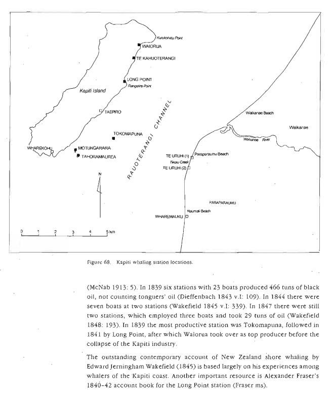
The existing Whale Song historical map distinguishes six offshore stations: Waiorua, Tokomapuna, Long Point, Te Kahuoterangi, Motungarara and Tahoramaurea; it separately marks mainland oil landing places at Te Uruhi and Wharemauku.
Six stations in one recorded year
The often-quoted 1839 snapshot describes six establishments, 23 boats and 466 tuns of black oil for the Kāpiti–Mana group, excluding tonguers. Dieffenbach’s account was subsequently assembled and interpreted by Nigel Prickett in The Archaeology of New Zealand Shore Whaling (2002), pp.83–97.
The leading station changed
Prickett identifies Tokomapuna as the most productive station in 1839, Long Point in 1841 and Waiorua thereafter. These changes remind us that stations were not equally productive or continuously occupied. The numbers describe particular reporting periods, not every station known archaeologically.
Boundaries of the return
The 1839 Kāpiti figures exclude tonguers. A station count is also not interchangeable with the number of visiting whaling ships or the number of separate boat crews working from the same shore base.
Source: Nigel Prickett, “The Archaeology of New Zealand Shore Whaling” (2002), pp. 83–97.
Explore connected books
Explore connected history
- A correspondent counts boats and oil at Kāpiti and Mana
- Four Europeans reported drowned off Mana
- Four whalers reported drowned off Mana
- Mana and Kāpiti catch figures later published
- Te Ara Kāpiti and Mana islands map
- 1839 whaling scale
- Whaling decline 1839 to 1847
- Do not conflate station counts
- How many whaling stations were operating around Kāpiti in 1839?
- Six stations, twenty-three boats and the whaling boom