A historical map preserves the locations of vanished stations
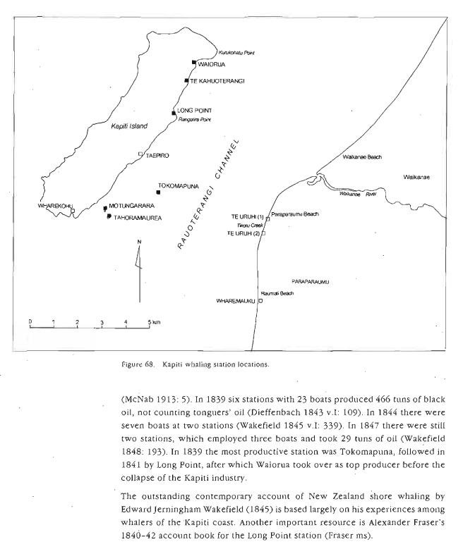
A circa-1965 map held by the Alexander Turnbull Library marks whaling stations, Māori settlements and place names on Kāpiti and neighbouring islands. Its catalogue description specifically links Tokomapuna with Evans’s station, Motungarara with Lewis’s, and Tahoramaurea with Mayhew’s. The map offers a valuable visual cross-check for the historical location index, but the catalogue warns that publication requires permission from the original owner.
Reading a map against the shoreline
A historic map can preserve a station name long after buildings have disappeared, but it is not an aerial photograph of the 1840s. Survey purpose, scale, shoreline changes and later annotations all affect what can be inferred. Nigel Prickett’s archaeological work provides a useful second line of evidence: stone hearths, trypot stands and habitation traces can sometimes be compared with written and cartographic descriptions. Where the two kinds of evidence disagree, the disagreement belongs in the historical record rather than being silently smoothed away.
Explore connected books
Explore connected history
- Six stations on Whale Song map
- Six stations, twenty-three boats and the whaling boom
- Stations and operators, scholarly interpretation
- Te Wai-o-Rongomai and Te Puna-o-Rongomai
- Waikanae naming traditions
- Whale Song, Kāpiti — Blood, Oil and Bone (2025)
- Puketapu ki Paraparaumu — History and Living Connections
- Modern whaling and whale watching
- Fraser’s Long Point station: an account book opens a lost world
- A whaling boom and a sudden collapse at Long Point
- Kāpiti whaling on credit: Antonio and Fitzherbert in court
- An Old New Zealander — T. Lindsay Buick (1911)