Tokomapuna: Evans’s station and an unresolved date conflict
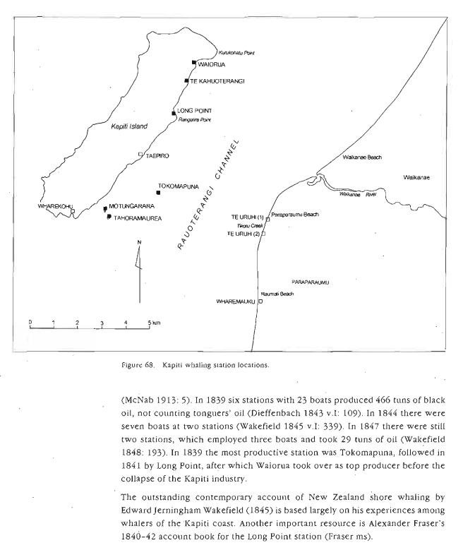
Heaphy’s coastal profile labels Tokomapuna Evans’s Island English Whaling Establishment. Prickett describes at least seven fireplaces, terraces, tryworks, a landing beach and possible grave. His narrative says Long Point produced 172 tuns in 1841, but the later Tokomapuna discussion says 172 tuns in 1840. The same report identifies 1841 as the likely year Thomas Evans worked at Long Point. Preserve both statements and flag the apparent date error; do not silently normalise it.
Dating a station from several kinds of evidence
Tokomapuna appears as an important station in the 1839 regional picture, when it was reported as the most productive station in the area. The archaeological remains and the surviving written accounts should nevertheless be treated as different kinds of evidence: a stone feature establishes physical activity, while a dated report may identify an operator, crew or season. Where two dates conflict, neither should be silently converted into a certainty. A careful history preserves the original chronology and explains the limits of each source.
Further reading: Nigel Prickett, The Archaeology of New Zealand Shore Whaling (2002), Kāpiti–Mana section, pp. 83–97.
Explore connected books
Reading the island itself
Tokomapuna was a small island between Kāpiti and the mainland, approximately 175 by 150 metres in Prickett’s description. Its low shoreline and sheltered landing among reefs supported a shore station; a higher point may have served as a lookout, though that is an archaeological interpretation rather than a documented watchman’s post. In 1982 Prickett recorded at least seven stone fireplaces, terraces, a boulder mound interpreted as tryworks, a possible grave and traces of revetting. Dense vegetation prevented a complete surface inventory. The word possible matters: a grave-shaped feature is not proof of an identified burial, just as a fireplace is not evidence for a named resident.
The documentary record identifies the place on Charles Heaphy’s 1839–40 coastal profile as Evans’s Island English Whaling Establishment. Prickett associates it with Tommy Evans and reports that in 1839 its six boats accounted for about half the 466 tuns of oil attributed to the six Kāpiti–Mana stations. This is a regional production comparison drawn from Dieffenbach’s account, not a count of six vessels anchored at the island. Later passages in the same archaeological report contain an apparent inconsistency about whether Long Point’s 172-tun season was 1840 or 1841. The station account summary explicitly identifies 1841; readers should retain the discrepancy pending comparison with the original Fraser manuscript. Source: Prickett (2002), pp. 94–95, section 9.9; Dieffenbach (1843), vol. I, p. 109, cited by Prickett.
Evidence standard: the cited source supports the historical account; unanswered questions are retained rather than filled with speculation.
Explore connected history
- Tokomapuna: Tommy Evans’s station in stone
- Tokomapuna: the physical remains of Tommy Evans’s station
- Prickett national archaeological inventory
- A whaling boom and a sudden collapse at Long Point
- Early offshore whaling at Kāpiti
- Korohiwa: a drowning, a proposed transfer and Wilson’s crew
- Long Point: a workforce and a shifting economy
- Waiorua: a large working settlement in decline
- Taepiro: whaling attribution withdrawn by its original researcher
- Wharekohu: Mayhew’s landholding is not proof of a whaling station
- Waiorua’s earlier land claim remains ambiguous
- The Archaeology of New Zealand Shore Whaling — Nigel Prickett (2002)
Follow this history into other books
Continue with these connected accounts. Each opens a separate book with its own evidence and perspective.